Thursday, May 3, 2012

Final Assesment

Coastal Landforms and Processes

The Coastal Landscapes of Jeju Island...now and in the future;

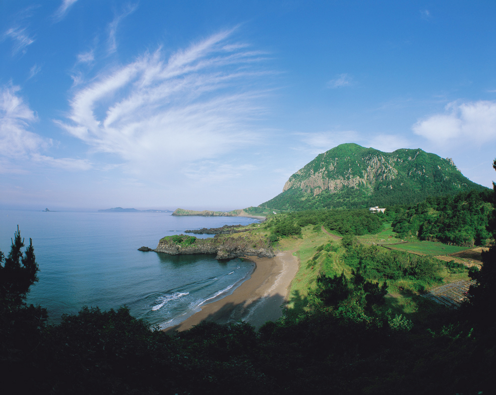
Shown above is a littoral zone found in Jeju Island that perfectly depicts the already well-known Hallasan Mountain. As I have labeled, the picture shows a few coastal forms and processes. In the backround, you can spot what looks to be a piece of land stretched out vertically into the water; this is called a tombolo which is a depositional landform; a landform created by material deposited by the water due the environment. To the right of the tombolo is an isolated pool of water called a lagoon and the stretch of sand seperating the lagoon from the body of water is called a bay barrier also formed by deposition.
Sanbang, Jeju Island
This is a coastal landform in Jeju called Sanbang. Here, you can see more of the same coastal landforms such as the depositional landform called a tombolo shown both in the far back of the picture beside the mountain and closer up near the beach. Also shown here is some coastal action; the spilling breakers just off the shoreline of Sanbang suggest that the bar beneath the water’s surface is flat. 


Sunrise Peak, Jeju Island
**Picture shows projected sea cliff to the left and back/sea cliff off of the beach to the right and front
Let’s begin to hypothisize what the coastal landscapes, such as the one above, will look like 10, 100, and 1000 years from now. Due to Jeju’s frequent storms that hit the island monthly, the best predictor for what coastal landforms in Jeju may look in the future will be determined by the erosion patterns displayed on the island. Erosional landforms are created by the breaking down of rock formations over time due to outside forces and conditions. For example, the sea cliff shown above can begin to develop what is called a notched cliff/wave-cut notch in 10 years. When the tide rises during storms, the forceful pounding of the water againts the cliff will form a u-shaped gap in the rock.
Diagram showing the process of the formation of a wave-cut notch
In a 100 years, those wave-cut notches can eventually form erosional landforms called sea caves. In the picture below you can see the formation of a sea-cave to the right of the landscape. 

Image of a sea cave on a coastal landscape in Jeju
As shown in the landscape above, the erosional coastal landscape in Jeju is completely diverse due to the frequent rain they recieve year-round that causes the tide to rise and damage the coast. The picture above proves that formations such as sea caves will begin to form over time and in Sunrise Peak’s case the notch’s that will begin to appear in 10 years should and will begin to develop into sea caves 100 years from now
1000 years from now, if the tide hits hard enough on the sea cliff shown in Sunrise Peak that is directly projected into the water (labeled beneath the image), the cliff could eventually break off completely and form a sea stack. Due to the weight of the cliff above the developing notch, the rock will detatch itself and become a completely separate entity. The picture below shows a sea stack on Udo-Island in Jeju.
Udo-Island Sea Stack
Images taken from:
http://nature.new7wonders.com/archives/wonder/jeju-island
http://geobytesgcse.blogspot.com/2007/08/coastal-erosion-landforms-features-and.html
Information taken from:
http://clasfaculty.ucdenver.edu/callen/1202/Landscapes/KarCoast/KarCoast.html

Thursday, April 12, 2012

Blog Entry #3

Jeju Island: HYDROLOGY

The Gotjawal Forest 
Dense Gotjawal Forest
The Gotjawal Forest covers approximately 86 square miles of Jeju Island. It is the direct water source for residents on the Island - providing for almot half a million people. The forest accumulates water through the diffusion of rainwater into the groundwater aquifer, this is permeable landform that water can be taken out of. Cracks in the basalt lava underneath the forest take in water and store it in layers underneath the forests surface. The area of storage where only water is stored within the pores is known as a saturated zone or the phreatic zone. There, water is stored within fragments of sediment beneath the aeration zone (vedos zone) layer. This layer is made up of both water and air directly underneath the Earth’s surface or in this case the lava beneath the Gotjawal Forest. 
Diagram 1 - Underground Aquifer
Drawdown & Recharge
Diagram 2 - Process of drawdown (water being extracted)
If the Island were to fall below the expected amount of rainfall throughout the year, the residents would suffer consequences from drawdown. Drawdown is the process of taking water out of the aquifers with the use of man made wells and pumping of the water. Without recharge, which is generally the process of refilling the aquifer with rainfall, the aquifer would stray from dynamic equilibrium which is when water being taken out is equal to the water being put in.


Compaction & Subsidence
Removal of water from an aquifer without recharge would eventually cause compaction which would lead to subsidence. Absence of water in the aquifer’s pores would cause the pieces of sediment to “compact.” As a result, the water table (level at which the water rises) would lower and the ground would follow (subside). The average amount of percipation in Jeju, as displayed below in row four of chart 1, shows that dynamic equilibrium should have been maintained in Jeju for many years because of constant monthly rainfall. The residents have yet to notice any signs of subsidence in the Gotjawal Forest and their water source remains reliable.
Climate data for Jeju-si, Jeju-do (1981−2010)
Month Jan Feb Mar Apr May Jun Jul Aug Sep Oct Nov Dec Year
Average high °C (°F) 8.3
(46.9)
9.4
(48.9)
12.8
(55.0)
17.5
(63.5)
21.6
(70.9)
24.8
(76.6)
29.0
(84.2)
29.8
(85.6)
25.8
(78.4)
21.3
(70.3)
16.0
(60.8)
11.0
(51.8)
18.9
(66.0)
Average low °C (°F) 3.2
(37.8)
3.6
(38.5)
6.1
(43.0)
10.2
(50.4)
14.4
(57.9)
18.7
(65.7)
23.3
(73.9)
24.3
(75.7)
20.4
(68.7)
15.1
(59.2)
9.8
(49.6)
5.3
(41.5)
12.9
(55.2)
Precipitation mm (inches) 65.2
(2.567)
62.6
(2.465)
88.6
(3.488)
89.6
(3.528)
96.4
(3.795)
181.4
(7.142)
239.9
(9.445)
262.5
(10.335)
221.6
(8.724)
80.3
(3.161)
61.9
(2.437)
47.7
(1.878)
1,497.6
(58.961)
humidity 65.3 64.9 64.9 66.5 70.4 76.8 78.3 76.5 73.7 66.9 65.1 65.1 69.6
Avg. precipitation days (≥ 0.1 mm) 12.6 10.3 11.2 10.0 10.4 11.8 12.5 13.5 10.8 7.0 9.3 10.8 130.2
Mean monthly sunshine hours 70.4 105.4 158.9 194.4 211.9 170.9 195.6 195.6 161.7 178.5 126.0 84.8 1,854.1
Source: Korea Meteorological Administration[11]
 Chart 1
Saturated forest surface after rainfall
Images taken from:
http://en.wikipedia.org/wiki/Jeju_Province
http://library.thinkquest.org/04oct/01590/humans/sources.html
http://en.wikipedia.org/wiki/File:Gotjawal_Forest.jpg
http://www.ramsar.org
http://dnr.wi.gov/org/water/dwg/OpCert/HTML/chapter3/wells4b.htm

Information taken from:
http://clasfaculty.ucdenver.edu/callen/1202/Battle/Destroy/Hydrology/HydrologyBasics.html
http://en.wikipedia.org/wiki/Jeju_Province

Thursday, March 8, 2012

Blog Entry #2

More on Baengnokdam...
Baengnokdam, the lake that sits on top of Hallasan Mountain, came to be as a result of a caldera. The creation of a caldera begins with an excessive amount of pressure build up in a volcano, that causes the top blow off. Once the magma from the explosion channels back into the central vent the cone of the volcano gives in, leaving a hollow bowl at the top of the mountain; this catches rainfall and forms a lake. 
Image of Baengnokdam
The volcanic geography of JeJu...
Dragon Head Coast
Local preparing goods on coast of Dragon Head near sill formation

A sill is an intrusive volcanic land form that develops when magma forces itself between rock layers and solidifies horizontally. The image below of Dragon Head Coast in Jeju shows a formation to the left that is made up of sills that formed far beneath the surface and were exposed over time due to erosion. The sills shown here are the result of what was a basalt lava flow.  
Exposed intrusive volcanic land form in Jeju

Yongduam (Dragon Head Rock)
Yongduam off of the coast of Jeju City

Similar to the description above of intrusive volcanic landforms, dikes are also created by lava that flows beneath the surface and hardens. The difference is that dikes are created when magma flow solidifies vertically rather than horizontally. Eventually, just like sills,  dikes become exposed formations that appear on landscapes after erosion has occurred. The exposure of these dikes can be small or larger such as the Dragon Head Rock in Jeju. The hardened and exposed basalt lava flow in this image shows a dike that took on the shape of what appears to look like a “dragon’s head” as the title of the rock suggests. 
Diagram showing process of dike and sill formation


Images taken from:
http://www.panoramio.com/photo/51186294
http://www.deweyhammond.com/2011/04/yongmeori-dragons-head-coast-jeju-do.html
http://alokalekhana.wordpress.com/2010/07/01/yong-duam-dragon-head-rock/
http://taishan.chinadaily.com.cn/e/2009-12/21/content_9206687.htm
http://www.geology.um.maine.edu


Information taken from:
http://clasfaculty.ucdenver.edu/callen/1202
http://www4.uwsp.edu/geo/faculty/ritter/geog101/textbook/volcanic_landforms/title_page.html

Tuesday, February 14, 2012

Blog Entry #1


“Jeju Island is Hallasan Mountain and Hallasan Mountain is Jeju Island”
Hallasan Mountain is the tallest mountain in South Korea standing tall at 1,950 meters (6,397 inches). The mountain takes up most of the Island, so therefore locals think Hallasan and Jeju to be one of the same; as the title of the post suggests. “Jeju Island is Hallasan Mountain and Hallasan Mountain is Jeju Island,” is a common saying amongst the people that habit-ate on its magnificent landscape.  
Map of South Korea
Hallasan Latitude: 33.3630556
Hallasan Longitude: 126.529722

The Mountain itself is a large shield volcano that has been dormant for many years. The mountain last erupted in 1002 and 1007 on the flank/side of the mountain which formed approximately 360 parasitic cones (cone shaped build up of volcanic material).
Hallasan Mountain
It came to be during the Cenozoic era, the last of the three geologic eras. It is the result of a series of eruptions from another volcano; basalt and trachyte lava allowed the island to build itself above sea level on the continental shelf. Basalt volcanic forms are categorized as mafic - shield volcanoes are one of the least explosive. It’s low viscosity would allow ample time for locals to escape the eruption. The viscosity of the volcano refers to the fluid flow. A shield volcano lets out pressure causing gas before erupting. 
Baengnokdam 
Lastly, the mountain has a volcanic crater that was also formed from an eruption. The crater holds a lake called Baengnokdam, which translates as “white deer lake.” Two kilometers in circumference and 100 meters deep is the largest the lake has ever gotten; the size of the lake fluctuates due to rainfall. 
More to come on Jeju Island and Hallasan in future blogs! 
Images taken from:
http://www.jitourism.com
http://www.thejakartapost.com
http://www.asiaclassictours.com/koreavacation
Information taken from:
http://en.wikipedia.org/wiki/Hallasan
http://san-shin.org/Jejudo-02.html
http://clasfaculty.ucdenver.edu/callen/1202/Battle/Build/VolcanicEx/Extrusive.html


Thursday, January 26, 2012

Introduction: Discover the Beauty of Jeju Island

Introduction 
By: Loraine Fishman
Jeju Island

I have decided to dedicate my blog to the breath taking landscape that is Jeju Island in South Korea... 
Hallasan Mountain

I chose Jeju Island because I am visiting there this summer. I am going abroad (Grenada sounds amazing too) with Professor Tony Robinson in the Political Science department and Jeju is the one of the last places we are going to visit on our trip. 


The picture above is of the beautiful Hallasan Mountain. It is one of the landforms on the Jeju that I want to visit as a geographer. Not only is it the tallest mountain in South Korea, but it is also volcanic and has been dormant for many years now. 


Along with Hallasan, there are many other forms and processes on the Island that I want to discover and learn more about. It will allow me to visit with a completely new set of eyes...exciting!


Images from...
http://www.screenok.com/wallpaper/jeju-island/
http://cinemaelectronica.wordpress.com/2011/08/16/jeju-island-us-imperialism-at-work/